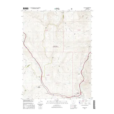
2016 Map of Vail Pass
USGS Topo · Published 2016About this map
Wheeler Junction serves as a focal point at the base of the Tenmile Range, marking a significant nexus of alpine transportation and recreation. This 2016 survey documents the high-altitude landscape where the Gore Range meets the developed corridors of the White River National Forest. The map detail captures the modern footprints of Copper Mountain and the steep passage through Vail Pass, contrasted with primitive routes like the Gore Creek Trail and Wheeler National Recreation Trail. Water features are prominent throughout the drainage basins, including the high-elevation Wheeler Lakes and the managed waters of Officers Gulch Pond. The terrain is characterized by dramatic shifts in elevation, from the heights of Uneva Peak down through Union Gulch, illustrating the intersection of natural topography with the infrastructure required for mountain travel and winter sports.
Find a feature on this map
55 named features on this map. Tap any name to fly to it.
Don’t see what you’re looking for? This feature index may not catch every label — zoom into the map to look around manually.
Map Details
Editions of this 2016 Vail Pass Map
This is the sole edition of this map. No revisions or reprints were ever made.
Other maps of this area

1889 · Leadville
USGS Topo · 1:125,000

1891 · Leadville
USGS Topo · 1:125,000

1929 · Dillon
USGS Topo · 1:62,500

1934 · Climax
USGS Topo · 1:48,000

1934 · Minturn
USGS Topo · 1:62,500

1934 · Dillon
USGS Topo · 1:62,500

1938 · Mt. Lincoln
USGS Topo · 1:48,000

1942 · Leadville
USGS Topo · 1:125,000

1945 · Mount Lincoln
USGS Topo · 1:62,500

1949 · Holy Cross
USGS Topo · 1:62,500