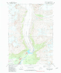
1983 Map of Valdez A-6 NW
USGS Topo · Published 1983About this map
Valdez Glacier Stream flows southward from the massive glacial ice fields, carving a wide alluvial path toward the Valdez Corporate Boundary in this 1983 topographic survey. The landscape is defined by the dramatic descent from the high peaks of Abercrombie Mountain and West Peak toward the coast, where the local infrastructure of Valdez begins to take shape. This sheet captures a critical interface between the raw glacial environment and human development, visible in the placement of the Airport, a Trailer Park, and various Mines and Gravel Pits that supported the area's growth during the early 1980s. The map meticulously documents the drainage patterns of Camicia Creek and Slater Creek as they navigate the debris-laden glacial margins. For researchers, the map provides precise data on the extents of the Camicia Glacier and Rabin Glacier during this specific era of Alaskan history.
Find a feature on this map
15 named features on this map. Tap any name to fly to it.
Don’t see what you’re looking for? This feature index may not catch every label — zoom into the map to look around manually.
Map Details
Editions of this 1983 Valdez A-6 NW Map
This is the sole edition of this map. No revisions or reprints were ever made.
Other maps of this area

1951 · Valdez B-6
USGS Topo · 1:63,360

1951 · Valdez A-6
USGS Topo · 1:63,360

1952 · Valdez
USGS Topo · 1:250,000

1952 · Valdez A-6
USGS Topo · 1:63,360

1953 · Valdez B-6
USGS Topo · 1:63,360

1960 · Valdez B-7
USGS Topo · 1:63,360

1960 · Valdez A-7
USGS Topo · 1:63,360

1960 · Valdez
USGS Topo · 1:250,000
1983 · Valdez A-6 SW
USGS Topo · 1:25,000
1983 · Valdez A-7 SE
USGS Topo · 1:25,000