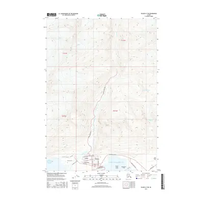
2016 Map of Valdez A-7 NE
USGS Topo · Published 2016About this map
Valdez sits at the edge of the Prince William Sound, serving as a critical coastal hub where the Richardson Highway meets the sea. This 2016 survey illustrates the modern layout of the city, including its grid of residential and commercial streets such as Egan Drive, Pioneer Drive, and Hazellet Avenue. The presence of the Prince William Sound Community College and Valdez Pioneer Field highlights the area's development as an educational and logistical center for the region.
Find a feature on this map
39 named features on this map. Tap any name to fly to it.
Don’t see what you’re looking for? This feature index may not catch every label — zoom into the map to look around manually.
Map Details
Editions of this 2016 Valdez A-7 NE Map
This is the sole edition of this map. No revisions or reprints were ever made.
Other maps of this area

1951 · Valdez B-6
USGS Topo · 1:63,360

1951 · Valdez A-6
USGS Topo · 1:63,360

1952 · Valdez
USGS Topo · 1:250,000

1952 · Valdez A-6
USGS Topo · 1:63,360

1953 · Valdez B-6
USGS Topo · 1:63,360

1960 · Valdez B-7
USGS Topo · 1:63,360

1960 · Valdez A-7
USGS Topo · 1:63,360

1960 · Valdez
USGS Topo · 1:250,000
1983 · Valdez A-6 SW
USGS Topo · 1:25,000
1983 · Valdez A-7 SE
USGS Topo · 1:25,000