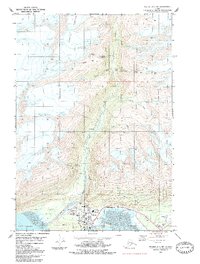
1983 Map of Valdez A-7 NE
USGS Topo · Published 1983About this map
Valdez sits at the head of Port Valdez, serving as a critical infrastructure hub where the Richardson Highway meets the sea. This 1980s-era survey documents a landscape defined by the transition from industrial mining roots to modern logistical operations. To the north, the steep valleys along Mineral Creek and its tributaries are dotted with the remnants of a hard-rock mining legacy, including the Big Four Mine, Hercules Mine, and the Johnson Mill (Ruins). The map details the shifted footprint of the settlement, noting both the established city center and New Town, alongside essential services like the Hospital and High Sch. Further inland, the massive Johnson Glacier dominates the upper elevations, feeding the network of creeks that carve through the Wood Creek drainage toward the coastal flats.
Find a feature on this map
33 named features on this map. Tap any name to fly to it.
Don’t see what you’re looking for? This feature index may not catch every label — zoom into the map to look around manually.
Map Details
Editions of this 1983 Valdez A-7 NE Map
This is the sole edition of this map. No revisions or reprints were ever made.
Other maps of this area

1951 · Valdez B-6
USGS Topo · 1:63,360

1951 · Valdez A-6
USGS Topo · 1:63,360

1952 · Valdez
USGS Topo · 1:250,000

1952 · Valdez A-6
USGS Topo · 1:63,360

1953 · Valdez B-6
USGS Topo · 1:63,360

1960 · Valdez B-7
USGS Topo · 1:63,360

1960 · Valdez A-7
USGS Topo · 1:63,360

1960 · Valdez
USGS Topo · 1:250,000
1983 · Valdez A-6 SW
USGS Topo · 1:25,000
1983 · Valdez A-7 SE
USGS Topo · 1:25,000