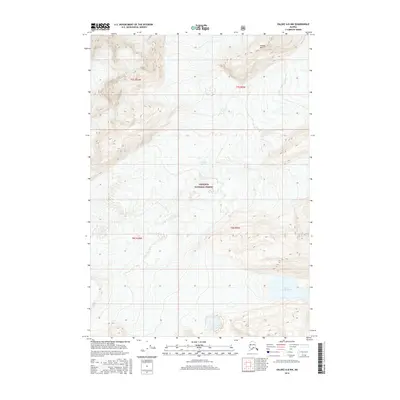
2016 Map of Valdez A-8 NW
USGS Topo · Published 2016About this map
The Columbia Glacier dominates this glacial landscape, showing the terminus and surrounding ice fields within the Chugach National Forest. The map provides a detailed topographic record of the shifting ice and rugged relief of the Unorganized Borough, where the ice meets the sea and the surrounding peaks. To the northeast, Divider Mtn rises as a prominent landmark amongst the steep contours, while Lake Number One sits in the lower elevations to the southeast. The survey area is defined by the intersections of t7s r9w, t7s r10w, t8s r9w, and t8s r10w, reflecting the vast, uninhabited terrain characteristic of this portion of Alaska. The dense contour lines illustrate the extreme elevation changes between the glaciated valleys and the sharp mountain ridges, providing a precise snapshot of the region's physical geography in the early twenty-first century.
Find a feature on this map
8 named features on this map. Tap any name to fly to it.
Don’t see what you’re looking for? This feature index may not catch every label — zoom into the map to look around manually.
Map Details
Editions of this 2016 Valdez A-8 NW Map
This is the sole edition of this map. No revisions or reprints were ever made.
Other maps of this area

1951 · Anchorage
USGS Topo · 1:250,000

1952 · Valdez
USGS Topo · 1:250,000

1960 · Valdez A-8
USGS Topo · 1:63,360

1960 · Anchorage A-1
USGS Topo · 1:63,360

1960 · Anchorage B-1
USGS Topo · 1:63,360

1960 · Valdez B-8
USGS Topo · 1:63,360

1960 · Valdez
USGS Topo · 1:250,000

1962 · Anchorage
USGS Topo · 1:250,000

1979 · Anchorage
USGS Topo · 1:250,000
1995 · Valdez A-8
USGS Topo · 1:63,360