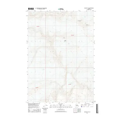
2016 Map of Valdez B-7 SE
USGS Topo · Published 2016About this map
Glacial ice dominates this high-altitude Alaskan landscape north of Valdez, where massive ice fields converge and carve the surrounding peaks. The massive Valdez Glacier and Klutina Glacier dominate the northern and central portions of the map, their frozen flow defining the drainage patterns toward the coast. These glaciers are flanked by prominent peaks, including Mt Logan, Mt Brookfield, and Mt Mahlo, which serve as permanent markers in this shifting icy terrain. Toward the southern extent, the map captures the headwaters of Mineral Cr, flowing from the Mineral Creek Glacier. This survey provides a precise record of the extent of these ice bodies, including the Stephens Glacier and Shoup Glacier, at a specific point in the early 21st century, offering a baseline for studying the changing character of Alaska’s coastal mountains.
Find a feature on this map
14 named features on this map. Tap any name to fly to it.
Don’t see what you’re looking for? This feature index may not catch every label — zoom into the map to look around manually.
Map Details
Editions of this 2016 Valdez B-7 SE Map
This is the sole edition of this map. No revisions or reprints were ever made.
Other maps of this area

1951 · Valdez B-6
USGS Topo · 1:63,360

1951 · Valdez A-6
USGS Topo · 1:63,360

1952 · Valdez
USGS Topo · 1:250,000

1952 · Valdez A-6
USGS Topo · 1:63,360

1953 · Valdez B-6
USGS Topo · 1:63,360

1960 · Valdez B-7
USGS Topo · 1:63,360

1960 · Valdez A-7
USGS Topo · 1:63,360

1960 · Valdez
USGS Topo · 1:250,000
1983 · Valdez A-6 NW
USGS Topo · 1:25,000
1983 · Valdez A-7 NE
USGS Topo · 1:25,000