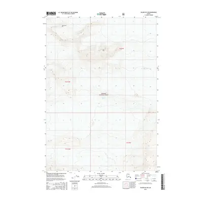
2016 Map of Valdez B-8 SW
USGS Topo · Published 2016About this map
High-altitude glacial features and steep coastal mountains dominate this portion of the Chugach National Forest near the Prince William Sound region. The landscape is defined by the massive Columbia Glacier, which flows through the southern half of the sheet, and the expansive Ted Stevens Icefield to the northeast. These ice-carved terrains are punctuated by sharp summits like Sharkstooth Mtn and Pilot Peak, illustrating the extreme topographical relief characteristic of the Chugach Range. The grid of the Public Land Survey System, including t6s r10w and t7s r9w, is superimposed over these ice flows and rocky ridges, marking out territory in a wilderness largely devoid of human infrastructure or permanent settlements. The map provides a precise record of glacial boundaries and elevation contours during the mid-2010s.
Find a feature on this map
9 named features on this map. Tap any name to fly to it.
Don’t see what you’re looking for? This feature index may not catch every label — zoom into the map to look around manually.
Map Details
Editions of this 2016 Valdez B-8 SW Map
This is the sole edition of this map. No revisions or reprints were ever made.
Other maps of this area

1951 · Anchorage
USGS Topo · 1:250,000

1952 · Valdez
USGS Topo · 1:250,000

1960 · Valdez A-8
USGS Topo · 1:63,360

1960 · Anchorage A-1
USGS Topo · 1:63,360

1960 · Anchorage B-1
USGS Topo · 1:63,360

1960 · Valdez B-8
USGS Topo · 1:63,360

1960 · Valdez
USGS Topo · 1:250,000

1962 · Anchorage
USGS Topo · 1:250,000

1979 · Anchorage
USGS Topo · 1:250,000
1995 · Valdez A-8
USGS Topo · 1:63,360