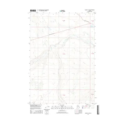
2016 Map of Valdez C-3 NW
USGS Topo · Published 2016About this map
Kenney Lake sits at the northeastern edge of this landscape, a vital point of reference in a region defined by its glacial hydrology and transport corridors. The Tonsina River cuts a wide, meandering path through the central terrain, its complex braided channels reflecting the heavy sediment loads typical of this Alaskan interior drainage. Along the northern boundary, the intersection of Edgerton Hwy/McCarthy Rd and Old Edgerton Loop Road highlights the evolution of travel in the Copper River basin, marking where modern infrastructure follows or diverges from earlier pioneer routes. Small seasonal drainages like Willow Cr and Dust Cr feed into the larger river system, which flows through a deeply contoured valley as it moves toward its eventual confluence downstream.
Find a feature on this map
12 named features on this map. Tap any name to fly to it.
Don’t see what you’re looking for? This feature index may not catch every label — zoom into the map to look around manually.
Map Details
Editions of this 2016 Valdez C-3 NW Map
This is the sole edition of this map. No revisions or reprints were ever made.
Other maps of this area

1949 · Valdez D-4
USGS Topo · 1:63,360

1951 · Valdez C-3
USGS Topo · 1:63,360

1951 · Valdez C-4
USGS Topo · 1:63,360

1952 · Valdez
USGS Topo · 1:250,000

1952 · Valdez D-4
USGS Topo · 1:63,360

1953 · Valdez C-3
USGS Topo · 1:63,360

1953 · Valdez C-4
USGS Topo · 1:63,360

1958 · Valdez D-3
USGS Topo · 1:63,360

1960 · Valdez
USGS Topo · 1:250,000
1996 · Valdez C-4
USGS Topo · 1:63,360