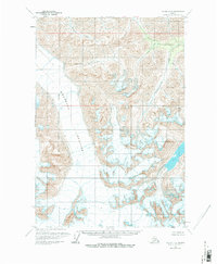
1960 Map of Valdez C-8
USGS Topo · Published 1980About this map
Nelchina Glacier dominates the southwestern portion of this Alaskan landscape, its massive ice field marked by numerous crevasses as it flows through high mountain passes. The 1960 field annotation captures a wilderness defined by glacial movement and the headwaters of vital drainages. To the north, Hornette Creek carves through the terrain, while the eastern reaches are defined by the winding course of Klanelneechena Creek. This survey also documents the Matanuska-Susitna Borough Boundary, which cuts across the glacial ice and surrounding ridges. The map reflects a period of aerial photography from the 1950s, detailing a remote region where the physical landscape is shaped by ice and high-altitude stream systems rather than human settlement.
Find a feature on this map
5 named features on this map. Tap any name to fly to it.
Don’t see what you’re looking for? This feature index may not catch every label — zoom into the map to look around manually.
Map Details
Editions of this 1960 Valdez C-8 Map
3 editions found

Other maps of this area

1948 · Anchorage D-1
USGS Topo · 1:63,360

1949 · Valdez D-8
USGS Topo · 1:63,360

1949 · Valdez D-7
USGS Topo · 1:63,360

1951 · Valdez D-7
USGS Topo · 1:63,360

1951 · Anchorage
USGS Topo · 1:250,000

1951 · Anchorage D-1
USGS Topo · 1:63,360

1952 · Valdez D-8
USGS Topo · 1:63,360

1952 · Valdez
USGS Topo · 1:250,000

1960 · Valdez B-7
USGS Topo · 1:63,360

1960 · Valdez C-7
USGS Topo · 1:63,360