
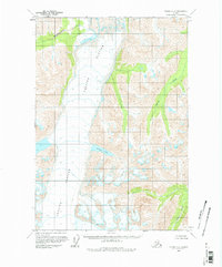
1960 Map of Valdez C-7
USGS Topo · Published 1965About this map
The Tazlina Glacier dominates this mid-century Alaskan landscape, its massive ice field marked by numerous crevasses that indicate the slow, powerful movement of the glacier. This environment is defined by its dramatic drainage systems, including the Iceberg Lake which sits along the glacier's eastern margin. The glacial runoff feeds into complex watercourses such as the Klanelneechena Creek to the northwest and the Kaina Creek and Hallet River to the east. Surveyed in the 1950s, the map reveals a wilderness without roads or trails, where the land lines were predetermined by the Bureau of Land Management rather than established by physical markers on the ground. The contour work captures the high-altitude relief of the surrounding peaks that overlook the glacier's wide path.
Find a feature on this map
6 named features on this map. Tap any name to fly to it.
Don’t see what you’re looking for? This feature index may not catch every label — zoom into the map to look around manually.
Map Details
Editions of this 1960 Valdez C-7 Map
2 editions found
Other maps of this area

1949 · Valdez D-8
USGS Topo · 1:63,360

1949 · Valdez D-6
USGS Topo · 1:63,360

1949 · Valdez D-7
USGS Topo · 1:63,360

1950 · Valdez C-6
USGS Topo · 1:63,360

1951 · Valdez D-6
USGS Topo · 1:63,360

1951 · Valdez D-7
USGS Topo · 1:63,360

1951 · Valdez B-6
USGS Topo · 1:63,360

1952 · Valdez D-8
USGS Topo · 1:63,360

1952 · Valdez
USGS Topo · 1:250,000

1953 · Valdez C-6
USGS Topo · 1:63,360