
1953 Map of Valdez C-6
USGS Topo · Published 1954About this map
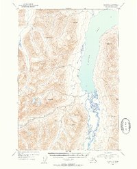
Klutina Lake dominates this glacial landscape, serving as the central reservoir for the northern Chugach region's drainage system. The high-altitude terrain is defined by prominent summits such as Powell Peak, Dyke Mtn, and Marshall Mtn, which frame the deep basin carved by the Klutina River. Evidence of early remote habitation is preserved in labels for isolated Cabin sites near the lake's western shore and the mouth of Curtis Gulch. The 1953 survey captures the complex hydrology of the valley, where the Hallet River feeds into the primary river system amidst a series of steep drainages and mountain massifs including Terrace Mtn and Mayer Peak. This map provides a clear record of the area's natural landmarks and rudimentary trails before modern recreational development, reflecting a time when surveying depended on high-altitude benchmarks like VABM Klu and VABM Mayer.
Find a feature on this map
14 named features on this map. Tap any name to fly to it.
Don’t see what you’re looking for? This feature index may not catch every label — zoom into the map to look around manually.
Map Details
Editions of this 1953 Valdez C-6 Map
2 editions found
Other maps of this area

1948 · Valdez D-5
USGS Topo · 1:63,360

1949 · Valdez D-6
USGS Topo · 1:63,360

1949 · Valdez D-7
USGS Topo · 1:63,360

1950 · Valdez C-6
USGS Topo · 1:63,360

1951 · Valdez D-5
USGS Topo · 1:63,360

1951 · Valdez D-6
USGS Topo · 1:63,360

1951 · Valdez D-7
USGS Topo · 1:63,360

1951 · Valdez B-5
USGS Topo · 1:63,360

1951 · Valdez C-5
USGS Topo · 1:63,360

1951 · Valdez B-6
USGS Topo · 1:63,360