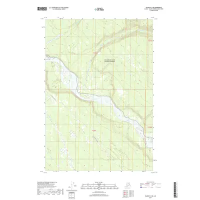
2019 Map of Valdez D-3 SW
USGS Topo · Published 2019About this map
The braided channels of the Copper River dominate this Alaskan landscape within the Wrangell-St. Elias National Preserve. The river system is fed by significant glacial tributaries including the Nadina River and Dadina River to the north, which carve through the high-elevation contours before meeting the main valley. This 2019 survey documents a vast area of the unorganized borough characterized by complex hydrography and minimal human infrastructure. The Old Edgerton Loop Road provides one of the few terrestrial transit markers in the southern portion of the quadrangle, tracing a path near Willow Cr and Rock Cr. This map is particularly valuable for understanding the modern drainage patterns and terrain of this protected wilderness area.
Find a feature on this map
11 named features on this map. Tap any name to fly to it.
Don’t see what you’re looking for? This feature index may not catch every label — zoom into the map to look around manually.
Map Details
Editions of this 2019 Valdez D-3 SW Map
This is the sole edition of this map. No revisions or reprints were ever made.
Other maps of this area

1949 · Valdez D-4
USGS Topo · 1:63,360

1951 · Valdez C-3
USGS Topo · 1:63,360

1951 · Valdez C-4
USGS Topo · 1:63,360

1952 · Valdez
USGS Topo · 1:250,000

1952 · Valdez D-4
USGS Topo · 1:63,360

1953 · Valdez C-3
USGS Topo · 1:63,360

1953 · Valdez C-4
USGS Topo · 1:63,360

1958 · Valdez D-3
USGS Topo · 1:63,360

1960 · Valdez
USGS Topo · 1:250,000
1996 · Valdez C-4
USGS Topo · 1:63,360