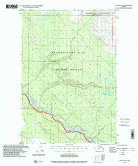
1996 Map of Valdez D-3
USGS Topo · Published 2001About this map
The Copper River corridor dominates this interior Alaskan landscape, serving as a vital geographical anchor between high mountain preserves. This 1996 update reveals the remote nature of the region, where the Old Edgerton Highway winds through the southwestern corner, passing through small outposts such as Kenny and near a Cabin site. The topography transitions from the river valley into the protected expanses of the Wrangell-Saint Elias National Preserve and the more restricted Wrangell-Saint Elias Wilderness. Drainage patterns are defined by the glacial paths of the Dadina River and Nadina River, which flow westward toward the main Copper channel. For researchers, the map provides a clear look at the intersection of early road infrastructure and modern conservation boundaries, including the quiet waters of Dadina Lake and the feeder streams of Willow Creek and Rock Creek.
Find a feature on this map
13 named features on this map. Tap any name to fly to it.
Don’t see what you’re looking for? This feature index may not catch every label — zoom into the map to look around manually.
Map Details
Editions of this 1996 Valdez D-3 Map
This is the sole edition of this map. No revisions or reprints were ever made.
Other maps of this area

1949 · Gulkana A-3
USGS Topo · 1:63,360

1949 · Valdez D-4
USGS Topo · 1:63,360

1951 · Gulkana
USGS Topo · 1:250,000

1951 · Valdez C-2
USGS Topo · 1:63,360

1951 · Valdez C-3
USGS Topo · 1:63,360

1951 · Valdez C-4
USGS Topo · 1:63,360

1952 · Gulkana A-3
USGS Topo · 1:63,360

1952 · Valdez
USGS Topo · 1:250,000

1952 · Valdez D-4
USGS Topo · 1:63,360

1953 · Valdez C-2
USGS Topo · 1:63,360