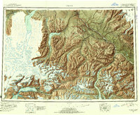
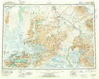
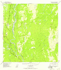
1952 Map of Valdez
USGS Topo · Published 1954About this map
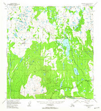
The Copper River and its vast glacial tributaries anchor this mid-century survey, illustrating the complex geography of the Third Judicial Division. Concentrated human activity appears at the coast in Valdez, where mining interests are represented by the Cliff Mine and various encampments like Ramsay-Rutherford Camp and Gold King Camp. Inland, the Richardson Highway serves as a vital corridor, connecting Copper Center and Willow Creek through the mountains.
Find a feature on this map
136 named features on this map. Tap any name to fly to it.
Don’t see what you’re looking for? This feature index may not catch every label — zoom into the map to look around manually.
Map Details
Editions of this 1952 Valdez Map
4 editions found


Other maps of this area

1948 · Cordova
USGS Topo · 1:250,000
1948 · Valdez D-5
USGS Topo · 1:63,360
1948 · Anchorage D-1
USGS Topo · 1:63,360
1949 · Gulkana A-3
USGS Topo · 1:63,360
1949 · Gulkana A-5
USGS Topo · 1:63,360
1949 · Talkeetna Mountains A-1
USGS Topo · 1:63,360
1949 · Valdez D-4
USGS Topo · 1:63,360
1949 · Gulkana A-6
USGS Topo · 1:63,360
1949 · Valdez D-8
USGS Topo · 1:63,360
1949 · Valdez D-6
USGS Topo · 1:63,360