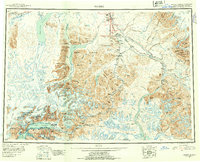
1952 Map of Valdez
USGS Topo · Published 1954About this map
Valdez serves as the coastal anchor for this mid-century reconnaissance of the Third Judicial Division, where the maritime activity of Port Valdez meets the rugged interior via the Richardson Highway. The map captures a landscape defined by glacier-fed waters and mining history, tracing the path from the coast over Thompson Pass toward the inland valley. A network of early industrial sites is visible, including remote outposts like Gold King Camp, Ramsay-Rutherford Camp, and the Cliff Mine along the shoreline.
Find a feature on this map
183 named features on this map. Tap any name to fly to it.
Don’t see what you’re looking for? This feature index may not catch every label — zoom into the map to look around manually.
Map Details
Editions of this 1952 Valdez Map
4 editions found

Other maps of this area

1948 · Cordova
USGS Topo · 1:250,000

1948 · Valdez D-5
USGS Topo · 1:63,360

1948 · Anchorage D-1
USGS Topo · 1:63,360

1949 · Gulkana A-3
USGS Topo · 1:63,360

1949 · Gulkana A-5
USGS Topo · 1:63,360

1949 · Talkeetna Mountains A-1
USGS Topo · 1:63,360

1949 · Valdez D-4
USGS Topo · 1:63,360

1949 · Gulkana A-6
USGS Topo · 1:63,360

1949 · Valdez D-8
USGS Topo · 1:63,360

1949 · Valdez D-6
USGS Topo · 1:63,360