
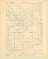
1906 Map of Vale
USGS Topo · Published 1906About this map
The Belle Fourche River meanders across this high plains landscape at the turn of the century, serving as the primary hydrological artery for a region transitioning into established ranching and agricultural use. Surveyed in 1904, the map reveals the sparse early settlement pattern of western South Dakota, anchored by the community of Vale and the isolated Butte Hall. The terrain is defined by an intricate network of drainages, including Whitewood Creek and Horse Creek, which carve through the land before joining the main river valley. A significant political boundary is noted where the Butte Co Meade Co Boundary Line bisects the territory. The presence of numerous bench marks and elevation points across the plains suggests the active work of U.S. Geological Survey topographers like Chester Irvine and J.E.Blackburn in documenting this open country before the expansion of modern infrastructure.
Find a feature on this map
12 named features on this map. Tap any name to fly to it.
Don’t see what you’re looking for? This feature index may not catch every label — zoom into the map to look around manually.
Map Details
Editions of this 1906 Vale Map
2 editions found
Other maps of this area

1893 · Rapid
USGS Topo · 1:125,000

1894 · Deadwood
USGS Topo · 1:125,000

1898 · Rapid
USGS Topo · 1:125,000

1899 · Sturgis
USGS Topo · 1:62,500

1901 · Deadwood
USGS Topo · 1:125,000

1903 · Rapid
USGS Topo · 1:125,000

1905 · Saint Onge
USGS Topo · 1:62,500

1906 · Two Top
USGS Topo · 1:62,500

1907 · Belle Fourche
USGS Topo · 1:125,000

1913 · Newell
USGS Topo · 1:125,000