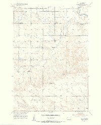
1951 Map of Vale SE
USGS Topo · Published 1953About this map
The Belle Fourche River and South Canal define the agricultural and hydraulic character of this western South Dakota landscape in the early 1950s. The northern reaches show a developing infrastructure supporting local farming communities, centered around Empire Ch and several rural schoolhouses including Empire Sch, Follette Sch, and Williamson Sch. Transport is anchored by the Chicago and North Western railroad corridor which cuts across the northern edge of the survey.
Find a feature on this map
13 named features on this map. Tap any name to fly to it.
Don’t see what you’re looking for? This feature index may not catch every label — zoom into the map to look around manually.
Map Details
Editions of this 1951 Vale SE Map
3 editions found
Other maps of this area

1893 · Rapid
USGS Topo · 1:125,000

1898 · Rapid
USGS Topo · 1:125,000

1903 · Rapid
USGS Topo · 1:125,000

1906 · Vale
USGS Topo · 1:62,500

1913 · Newell
USGS Topo · 1:125,000

1951 · Volunteer
USGS Topo · 1:24,000

1951 · Vale
USGS Topo · 1:24,000

1951 · Vale SE
USGS Topo · 1:24,000

1951 · Newell
USGS Topo · 1:24,000

1951 · Vale NE
USGS Topo · 1:24,000