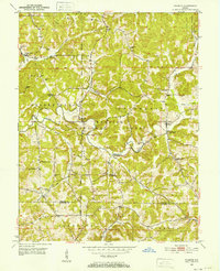
1950 Map of Valeene
USGS Topo · Published 1969About this map
The Patoka River winds through the hills of southern Indiana in this mid-century survey, cutting a path through the Hoosier National Forest. The landscape is defined by its deep hollows, including Underwood Hollow and Bird Hollow, which dictate the placement of small rural communities and family-named landmarks. The Second Principal Meridian and the Base Line intersect here, providing a glimpse into the foundational surveying grid that organized the frontier.
Find a feature on this map
40 named features on this map. Tap any name to fly to it.
Don’t see what you’re looking for? This feature index may not catch every label — zoom into the map to look around manually.
Map Details
Editions of this 1950 Valeene Map
3 editions found
Other maps of this area

1947 · Hardinsburg
USGS Topo · 1:24,000

1948 · Milltown
USGS Topo · 1:24,000

1949 · Hardinsburg
USGS Topo · 1:24,000

1950 · Valeene
USGS Topo · 1:24,000

1950 · English
USGS Topo · 1:24,000

1951 · French Lick
USGS Topo · 1:24,000

1956 · Greenbrier
USGS Topo · 1:24,000

1956 · Taswell
USGS Topo · 1:24,000

1956 · Vincennes
USGS Topo · 1:250,000

1957 · Vincennes
USGS Topo · 1:250,000