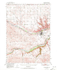
1950 Map of Valentine
USGS Topo · Published 1972About this map
The Niobrara River carves a deep valley across this Cherry County landscape, serving as a focal point for settlement and industry during the mid-century era. The city of Valentine sits at the convergence of this waterway and Minnechaduza Creek, supporting a local economy tied to the Chicago and North Western railroad and the State Experimental Farm. To the north and west, the vast Table upland is dotted with dozens of rural schoolhouses, such as School No 56 and School No 12, indicating a once-dense population of homesteading families.
Find a feature on this map
39 named features on this map. Tap any name to fly to it.
Don’t see what you’re looking for? This feature index may not catch every label — zoom into the map to look around manually.
Map Details
Editions of this 1950 Valentine Map
2 editions found
Other maps of this area

1950 · Sparks
USGS Topo · 1:62,500

1950 · Simeon
USGS Topo · 1:62,500

1950 · Kennedy
USGS Topo · 1:62,500

1950 · Kilgore
USGS Topo · 1:62,500

1950 · Arabia
USGS Topo · 1:62,500

1950 · Valentine
USGS Topo · 1:62,500

1955 · Martin
USGS Topo · 1:250,000

1957 · Valentine
USGS Topo · 1:250,000

1958 · Martin
USGS Topo · 1:250,000

1959 · Valentine
USGS Topo · 1:250,000