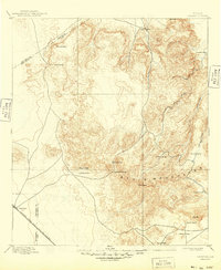
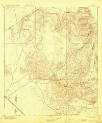
1897 Map of Valentine
USGS Topo · Published 1949About this map
The high Chihuahuan Desert and the towering Davis Mountains define this late 19th-century reconnaissance of Far West Texas. The landscape is characterized by a sparse network of isolated cattle ranches, including Newman's Ranch and Evans Ranch, reflecting the early pastoral settlement patterns of the Trans-Pecos region. In the southwest corner, the town of Valentine serves as a vital outpost along the Southern Pacific R. R. (G. H. and S. A. Div.), illustrating the total reliance of these remote communities on the railroad for logistics and contact with the outside world.
Find a feature on this map
25 named features on this map. Tap any name to fly to it.
Don’t see what you’re looking for? This feature index may not catch every label — zoom into the map to look around manually.
Map Details
Editions of this 1897 Valentine Map
6 editions found
Other maps of this area

1892 · Chispa
USGS Topo · 1:125,000

1894 · Valentine
USGS Topo · 1:125,000

1894 · Fort Davis
USGS Topo · 1:125,000

1895 · Chispa
USGS Topo · 1:125,000

1895 · Marfa
USGS Topo · 1:125,000

1895 · Alpine
USGS Topo · 1:125,000

1896 · San Carlos
USGS Topo · 1:125,000

1897 · Valentine
USGS Topo · 1:125,000

1897 · Fort Davis
USGS Topo · 1:125,000

1897 · Chispa
USGS Topo · 1:125,000