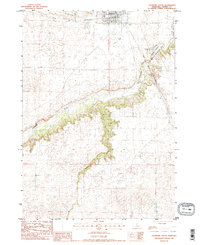
1983 Map of Valentine South
USGS Topo · Published 1984About this map
Valentine serves as the northern anchor of this landscape, situated just south of the winding Minnechaduza Creek. The geography is defined by the deep incision of the Niobrara River, which snakes across the central portion of the map, flanked by steep, intricate canyon walls. To the south, Schlegel Creek carves another significant drainage path through the Nebraska Sandhills. This 1983 survey captures the transition from the organized town grid and its surrounding agricultural land into the protected wilderness of the Fort Niobrara National Wildlife Refuge and the Borman Bridge Wildlife Management Area.
Find a feature on this map
21 named features on this map. Tap any name to fly to it.
Don’t see what you’re looking for? This feature index may not catch every label — zoom into the map to look around manually.
Map Details
Editions of this 1983 Valentine South Map
2 editions found
Other maps of this area

1950 · Sparks
USGS Topo · 1:62,500

1950 · Simeon
USGS Topo · 1:62,500

1950 · Arabia
USGS Topo · 1:62,500

1950 · Valentine
USGS Topo · 1:62,500

1957 · Valentine
USGS Topo · 1:250,000

1959 · Valentine
USGS Topo · 1:250,000
1983 · Crookston East
USGS Topo · 1:24,000

1983 · Valentine SW
USGS Topo · 1:24,000
1983 · Valentine North
USGS Topo · 1:24,000

1983 · Valentine South
USGS Topo · 1:24,000