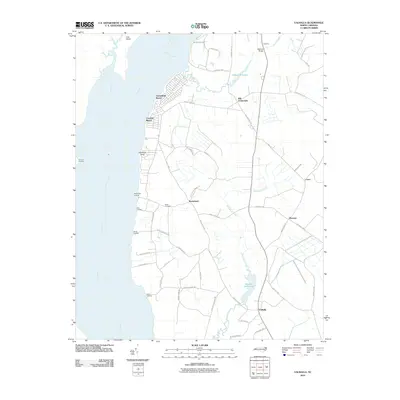
2010 Map of Valhalla
USGS Topo · Published 2010About this map
Chowan River dominates the western edge of this coastal plain landscape, where its wide waters meet a series of landings and community points. Residential developments such as Arrowhead Beach and Chowan Beach represent the modern growth of the shoreline, while the interior remains defined by older agricultural and water-management patterns. The map highlights numerous small settlements connected by a web of local roads, including Valhalla, Rockyhock, and Cisco. Significant water bodies like Dillard Millpond and Bennett Mill Pond suggest the historic importance of mill operations along Rockyhock Creek and its tributaries. Local history is further grounded by the Nixon Cemetery and family-named landmarks like Johnsons Point. The presence of multiple river access points, such as White Landing and Harris Landing, underscores a long-standing reliance on the river for transport and commerce in this corner of North Carolina.
Find a feature on this map
55 named features on this map. Tap any name to fly to it.
Don’t see what you’re looking for? This feature index may not catch every label — zoom into the map to look around manually.
Map Details
Editions of this 2010 Valhalla Map
This is the sole edition of this map. No revisions or reprints were ever made.
Other maps of this area

1904 · Edenton
USGS Topo · 1:62,500

1906 · Beckford
USGS Topo · 1:48,000

1907 · Beckford
USGS Topo · 1:62,500

1908 · Winton
USGS Topo · 1:62,500

1940 · Beckford
USGS Topo · 1:62,500

1942 · Edenton
USGS Topo · 1:62,500

1943 · Edenton
USGS Topo · 1:62,500

1953 · Norfolk
USGS Topo · 1:250,000
1981 · Edenton
USGS Topo · 1:24,000
1982 · Valhalla
USGS Topo · 1:24,000