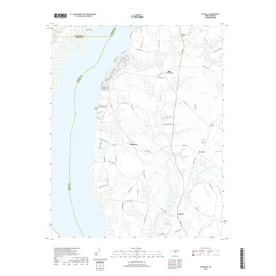
2019 Map of Valhalla
USGS Topo · Published 2019About this map
The Chowan River defines the western edge of this coastal plain landscape, where the Chowan and Bertie county lines meet mid-stream. In the northern reaches, Dillard Millpond and Billard Creek feed into a network of wetlands and tributaries like Rockyhock Cr and Pollock Swamp. The settlement pattern is characterized by small interior crossroads and landings, including Mill Crossroads, Rockyhock, and the namesake Valhalla near the southern boundary. Along the riverfront at Johnsons Point, a dense network of roads with tribal names such as Arapahoe Trl and Pocahontas Trl suggests a modern residential development integrated into the shoreline. Local infrastructure is represented by Lee's Airport and the crossing at Ballards Bridge, while the Nixon Cem provides a point of interest for those researching the area's family histories.
Find a feature on this map
81 named features on this map. Tap any name to fly to it.
Don’t see what you’re looking for? This feature index may not catch every label — zoom into the map to look around manually.
Map Details
Editions of this 2019 Valhalla Map
This is the sole edition of this map. No revisions or reprints were ever made.
Other maps of this area

1904 · Edenton
USGS Topo · 1:62,500

1906 · Beckford
USGS Topo · 1:48,000

1907 · Beckford
USGS Topo · 1:62,500

1908 · Winton
USGS Topo · 1:62,500

1940 · Beckford
USGS Topo · 1:62,500

1942 · Edenton
USGS Topo · 1:62,500

1943 · Edenton
USGS Topo · 1:62,500

1953 · Norfolk
USGS Topo · 1:250,000
1981 · Edenton
USGS Topo · 1:24,000
1982 · Valhalla
USGS Topo · 1:24,000