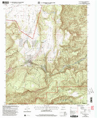
2002 Map of Vallecitos
USGS Topo · Published 2003About this map
Town of Abiquiu Grant lands dominate the northwestern portion of this Rio Arriba County landscape, where the settlement of Vallecitos serves as a local hub. The terrain is defined by dramatic elevation shifts across Lobato Mesa and the complex drainage of the Santa Fe National Forest. High-country water management is evident through numerous livestock tanks such as Cuchillas Tank and Vallecitos del los Chamisos Tank.
Find a feature on this map
48 named features on this map. Tap any name to fly to it.
Don’t see what you’re looking for? This feature index may not catch every label — zoom into the map to look around manually.
Map Details
Editions of this 2002 Vallecitos Map
This is the sole edition of this map. No revisions or reprints were ever made.
Other maps of this area

1892 · Santa Clara
USGS Topo · 1:125,000

1918 · Abiquiu
USGS Topo · 1:125,000

1952 · Valle Toledo
USGS Topo · 1:24,000

1952 · Puye
USGS Topo · 1:24,000

1952 · Guaje Mountain
USGS Topo · 1:24,000

1953 · Canones
USGS Topo · 1:24,000

1953 · Chili
USGS Topo · 1:24,000

1953 · Abiquiu
USGS Topo · 1:24,000

1953 · Medanales
USGS Topo · 1:24,000

1953 · Vallecitos
USGS Topo · 1:24,000