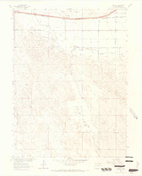
1963 Map of Vallery
USGS Topo · Published 1965About this map
Vallery Oil Field and the Ashley Oil and Gas Field dominate this 1963 survey of Morgan County, showing a landscape defined by petroleum extraction and irrigated agriculture. The northern boundary is marked by the path of the Chicago Burlington and Quincy railroad, which parallels the winding Bijou Creek. Small settlements like Vallery and Griffin serve as nodes along the rail line, while a Gas Plant and numerous wells scattered across the terrain indicate the industrial footprint of the era. Water management is central to the area's development, evidenced by the Bijou Canal and the natural drainage of San Arroyo Creek. The map also preserves traces of older transit patterns, including a stretch labeled Old Road that runs roughly parallel to the modern rail corridor, offering a glimpse into the evolving infrastructure of the High Plains.
Find a feature on this map
11 named features on this map. Tap any name to fly to it.
Don’t see what you’re looking for? This feature index may not catch every label — zoom into the map to look around manually.
Map Details
Editions of this 1963 Vallery Map
3 editions found

Other maps of this area

1950 · Wiggins
USGS Topo · 1:24,000

1950 · Hoyt
USGS Topo · 1:24,000

1951 · Hoyt
USGS Topo · 1:24,000

1951 · Weldona
USGS Topo · 1:24,000

1951 · Orchard
USGS Topo · 1:24,000

1951 · Fort Morgan
USGS Topo · 1:24,000

1954 · Sterling
USGS Topo · 1:250,000

1954 · Greeley
USGS Topo · 1:250,000

1957 · Greeley
USGS Topo · 1:250,000

1958 · Greeley
USGS Topo · 1:250,000