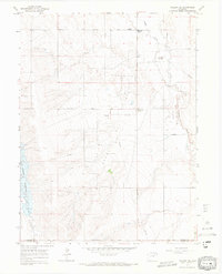
1965 Map of Vallery SE
USGS Topo · Published 1967About this map
Adena Field and its surrounding infrastructure define this mid-1960s landscape along the border of Morgan and Adams Counties. The presence of a Gasoline Plant, Storage Bins, and an extensive network of pipelines highlights the industrial energy development of the era, contrasting with the remote agricultural character of the high plains. Local transit and navigation are anchored by named intersections such as Ninemile Corner and Twelvemile Corner, which align with the straight-ruled courses of Ninemile Road and Twelvemile Road. Near the settlement of Adena Station, the Adena Sch remains a vital community landmark. The drainage of Badger Creek and the western presence of Rosener Reservoir provide the primary water features in this arid region, where the terrain is marked by the winding paths of San Arroyo Creek and Bridger Creek.
Find a feature on this map
20 named features on this map. Tap any name to fly to it.
Don’t see what you’re looking for? This feature index may not catch every label — zoom into the map to look around manually.
Map Details
Editions of this 1965 Vallery SE Map
3 editions found
Other maps of this area

1954 · Limon
USGS Topo · 1:250,000

1954 · Sterling
USGS Topo · 1:250,000

1957 · Limon
USGS Topo · 1:250,000

1958 · Limon
USGS Topo · 1:250,000

1958 · Sterling
USGS Topo · 1:250,000

1963 · Lamb
USGS Topo · 1:24,000

1963 · Round Top
USGS Topo · 1:24,000

1963 · Vallery
USGS Topo · 1:24,000

1963 · Adena
USGS Topo · 1:24,000

1965 · Vallery SE
USGS Topo · 1:24,000