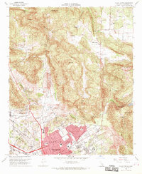
1968 Map of Valley Center
USGS Topo · Published 1970About this map
The growing city of Escondido anchors the southern portion of this late 1960s survey, showing its rapid expansion through neighborhoods like Rincon del Diablo and the developing area of Jesmond Dene. Significant local infrastructure is present, including Palomar Memorial Hospital and numerous educational institutions such as Escondido High Sch and Christian Day Sch (Luth). To the north, the community of Valley Center retains a more rural character, situated near the Oat Hills and the winding Moosa Canyon.
Find a feature on this map
60 named features on this map. Tap any name to fly to it.
Don’t see what you’re looking for? This feature index may not catch every label — zoom into the map to look around manually.
Map Details
Editions of this 1968 Valley Center Map
4 editions found
Other maps of this area

1893 · Escondido
USGS Topo · 1:62,500

1901 · Escondido
USGS Topo · 1:62,500

1901 · San Luis Rey
USGS Topo · 1:125,000

1903 · Ramona
USGS Topo · 1:125,000

1904 · Southern California Sheet No. 2
USGS Topo · 1:250,000

1939 · Palomar Mountain
USGS Topo · 1:62,500

1942 · Temecula
USGS Topo · 1:62,500

1942 · Escondido
USGS Topo · 1:62,500

1942 · Ramona
USGS Topo · 1:62,500

1947 · Ramona
USGS Topo · 1:62,500