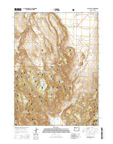
2014 Map of Valley Falls
USGS Topo · Published 2014About this map
Valley Falls serves as the focal point for this landscape where the Fremont Hwy and Us-395 converge at the base of the prominent Abert Rim. The area is characterized by a complex network of high-elevation plateaus and water management features, including the Coyote Flat Reservoir and Reynolds Reservoir. Large portions of the territory are managed by the Fremont National Forest, preserving a terrain defined by seasonal water sources and distinct landforms such as Indian Spring Ridge and Coyote Flat.
Find a feature on this map
41 named features on this map. Tap any name to fly to it.
Don’t see what you’re looking for? This feature index may not catch every label — zoom into the map to look around manually.
Map Details
Editions of this 2014 Valley Falls Map
This is the sole edition of this map. No revisions or reprints were ever made.
Other maps of this area

1955 · Klamath Falls
USGS Topo · 1:250,000

1958 · Klamath Falls
USGS Topo · 1:250,000

1964 · Crooked Creek Valley
USGS Topo · 1:24,000

1964 · Valley Falls
USGS Topo · 1:24,000

1964 · Clover Flat
USGS Topo · 1:24,000

1964 · Big Baldy
USGS Topo · 1:24,000

1966 · Tucker Hill
USGS Topo · 1:24,000

1966 · Coglan Buttes SE
USGS Topo · 1:24,000

1968 · Crook Peak
USGS Topo · 1:24,000

1968 · Lake Abert South
USGS Topo · 1:24,000