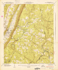
1947 Map of Valley Head
USGS Topo · Published 1947About this map
The Alabama Great Southern Railroad serves as a primary north-south artery through the rugged corridor of Dugout Valley, connecting the settlements of Hammondville and Valley Head. This 1947 record captures a landscape defined by the Tennessee Valley Divide, where the heights of Lookout Mountain drop away toward the twisting course of the Little River. The area is notably dotted with community institutions, from the Davenport Chapel School to the rustic Camp De Soto and Lookout Mtn Camp. To the south, the terrain becomes more protected as it enters De Soto State Park, highlighting landmarks like De Soto Falls and Little Falls. Genealogists will find significant value in the distribution of family-named sites such as Jones Cem and Ellison Cem, alongside small local churches like Johns Chapel and the Violet Hill Ch that anchored these upland communities.
Find a feature on this map
65 named features on this map. Tap any name to fly to it.
Don’t see what you’re looking for? This feature index may not catch every label — zoom into the map to look around manually.
Map Details
Editions of this 1947 Valley Head Map
2 editions found
Other maps of this area

1886 · Ringgold
USGS Topo · 1:125,000

1886 · Rome
USGS Topo · 1:125,000

1886 · Stevenson
USGS Topo · 1:125,000

1892 · Ringgold
USGS Topo · 1:125,000

1892 · Stevenson
USGS Topo · 1:125,000

1893 · Fort Payne
USGS Topo · 1:125,000

1895 · Stevenson
USGS Topo · 1:125,000

1898 · Rome
USGS Topo · 1:125,000

1898 · Fort Payne
USGS Topo · 1:125,000

1899 · Rome
USGS Topo · 1:125,000