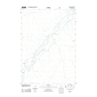
2012 Map of Valley
USGS Topo · Published 2012About this map
The S Fork Shoshone River carves a deep valley through this corner of Park County, where the small settlements of Valley and Hawkeye anchor a remote mountain landscape. This 2012 survey illustrates a region defined by its water and high-elevation terrain, featuring a network of tributaries including Ishawooa Cr, Schoolhouse Cr, and Little Boulder Cr. The presence of the McLaughlin Ditch suggests an agricultural reliance on these waterways, channeling the river's flow into the arid land. Local history is preserved at the Valley Cem and along the historic route of Valley Ranch Rd. For those exploring the wilderness near Slide Mountain, the map documents established sites like the Deer Creek Campground and numerous family-named landmarks like Legg Cr and Aldrich Cr.
Find a feature on this map
23 named features on this map. Tap any name to fly to it.
Don’t see what you’re looking for? This feature index may not catch every label — zoom into the map to look around manually.
Map Details
Editions of this 2012 Valley Map
This is the sole edition of this map. No revisions or reprints were ever made.
Other maps of this area

1893 · Ishawooa
USGS Topo · 1:125,000

1895 · Ishawooa
USGS Topo · 1:125,000

1899 · Ishawooa
USGS Topo · 1:125,000

1955 · Cody
USGS Topo · 1:250,000

1957 · Wapiti
USGS Topo · 1:62,500

1957 · Irish Rock
USGS Topo · 1:62,500

1958 · Cody
USGS Topo · 1:250,000

1962 · Cody
USGS Topo · 1:250,000
1970 · Fall Creek
USGS Topo · 1:24,000
1970 · Ptarmigan Mountain
USGS Topo · 1:24,000