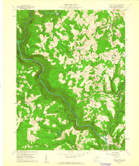
1959 Map of Valley Point
USGS Topo · Published 1961About this map
The Old Virginia Furnace stands as a testament to the industrial heritage of this Preston County landscape, situated near the confluence of Muddy Creek and Crab Orchard Creek. In the late 1950s, the terrain was defined by the winding course of the Cheat River, which carves a deep valley through Hogback Ridge. The map reveals a transition toward modern industrial activity, with numerous Strip Mines and individual Mine entries scattered throughout the Pleasant and Valley districts. Rural life is anchored by small settlements like Valley Point and Rockville, while a dense network of country churches including Harmony Grove Ch and Mt Union Ch serves as a vital resource for genealogists tracing local families. Notable landmarks like Chippewa Lake and the Old Grade Railroad further illustrate the evolving utility of the land.
Find a feature on this map
50 named features on this map. Tap any name to fly to it.
Don’t see what you’re looking for? This feature index may not catch every label — zoom into the map to look around manually.
Map Details
Editions of this 1959 Valley Point Map
4 editions found
Other maps of this area

1886 · St. George
USGS Topo · 1:125,000

1891 · St. George
USGS Topo · 1:125,000

1902 · Morgantown
USGS Topo · 1:62,500

1904 · Bruceton
USGS Topo · 1:62,500

1907 · Thornton
USGS Topo · 1:62,500

1907 · Kingwood
USGS Topo · 1:62,500

1925 · Kingwood
USGS Topo · 1:62,500

1925 · Morgantown
USGS Topo · 1:62,500

1926 · Thornton
USGS Topo · 1:62,500

1926 · Bruceton
USGS Topo · 1:62,500