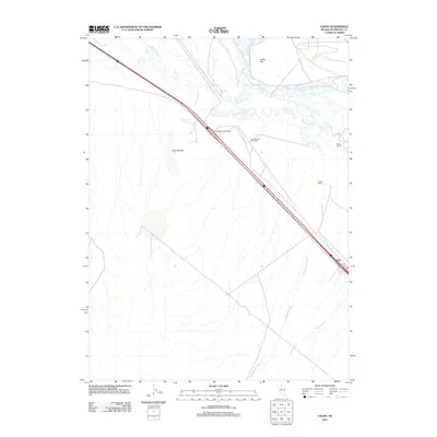
2011 Map of Valmy
USGS Topo · Published 2011About this map
Valmy serves as the primary settlement on this high-desert Nevada landscape, situated along the corridor where the interstate and modern infrastructure intersect with historical landmarks. The map documents the persistent importance of water sources in this arid region, from the meandering path of the Humboldt River and the braided channels of Herrin Slough to secluded points like Stonehouse Spring and Plank Spring. The presence of the Stone House Post Office and Valmy Post Office highlights the settlement history of the Humboldt County area, marking points of communication and commerce that have long served local travelers and residents.
Find a feature on this map
15 named features on this map. Tap any name to fly to it.
Don’t see what you’re looking for? This feature index may not catch every label — zoom into the map to look around manually.
Map Details
Editions of this 2011 Valmy Map
This is the sole edition of this map. No revisions or reprints were ever made.
Other maps of this area

1932 · Sonoma Range
USGS Topo · 1:250,000

1939 · Sonoma Range
USGS Topo · 1:250,000

1940 · Antler Peak
USGS Topo · 1:62,500

1943 · Antler Peak
USGS Topo · 1:62,500

1955 · Winnemucca
USGS Topo · 1:250,000

1958 · Winnemucca
USGS Topo · 1:250,000

1962 · Winnemucca
USGS Topo · 1:250,000

1965 · Knight
USGS Topo · 1:24,000

1965 · Edna Mountain
USGS Topo · 1:62,500
1965 · Brooks Spring
USGS Topo · 1:24,000