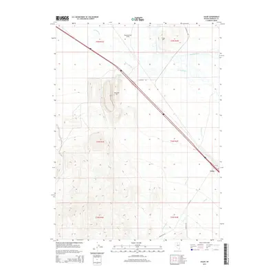
2014 Map of Valmy
USGS Topo · Published 2014About this map
Valmy sits at a critical junction of transportation and topography in the high desert, where the corridor of the Humboldt River shapes the local economy and infrastructure. In the early 21st century, this landscape is defined by its industrial and natural landmarks, including the prominent Lone Tree Hill and the vast Pumpernickel Valley to the north. The presence of Marigold Mine and several named springs, such as Stonehouse Spring and Plank Spring, highlights the persistent importance of mineral and water resources in this arid environment. Hydrological features like Herrin Slough, Cottonwood Cr, and Trout Cr cut through the terrain, illustrating the drainage patterns that influence travel along Stonehouse Hwy and Valmy Rd. Higher elevations are marked by Treaty Hill, providing a geographical anchor for the surrounding township and range survey lines.
Find a feature on this map
20 named features on this map. Tap any name to fly to it.
Don’t see what you’re looking for? This feature index may not catch every label — zoom into the map to look around manually.
Map Details
Editions of this 2014 Valmy Map
This is the sole edition of this map. No revisions or reprints were ever made.
Other maps of this area

1932 · Sonoma Range
USGS Topo · 1:250,000

1939 · Sonoma Range
USGS Topo · 1:250,000

1940 · Antler Peak
USGS Topo · 1:62,500

1943 · Antler Peak
USGS Topo · 1:62,500

1955 · Winnemucca
USGS Topo · 1:250,000

1958 · Winnemucca
USGS Topo · 1:250,000

1962 · Winnemucca
USGS Topo · 1:250,000

1965 · Knight
USGS Topo · 1:24,000

1965 · Edna Mountain
USGS Topo · 1:62,500
1965 · Brooks Spring
USGS Topo · 1:24,000