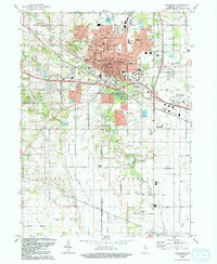
1992 Map of Valparaiso
USGS Topo · Published 1992About this map
Valparaiso serves as the focal point of this Porter County landscape, showing the city's significant expansion and the prominent campus of Valparaiso University. The map captures a transition from urban development to the surrounding rural townships, where long-standing community landmarks like Shults-Lewis Childrens Home and the Fairground stand alongside residential growth. Significant drainage systems including Salt Creek and Beauty Creek wind through the terrain, illustrating the hydrological management required for the region's agricultural and suburban development.
Find a feature on this map
66 named features on this map. Tap any name to fly to it.
Don’t see what you’re looking for? This feature index may not catch every label — zoom into the map to look around manually.
Map Details
Editions of this 1992 Valparaiso Map
This is the sole edition of this map. No revisions or reprints were ever made.
Other maps of this area

1934 · Porter
USGS Topo · 1:48,000

1940 · Porter
USGS Topo · 1:62,500

1953 · Palmer
USGS Topo · 1:24,000

1953 · Wanatah
USGS Topo · 1:24,000

1953 · Hebron
USGS Topo · 1:24,000

1953 · Garyton
USGS Topo · 1:24,000

1953 · Westville
USGS Topo · 1:24,000

1953 · Valparaiso
USGS Topo · 1:24,000

1953 · Chesterton
USGS Topo · 1:24,000

1953 · Kouts
USGS Topo · 1:24,000