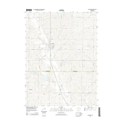
2014 Map of Valparaiso
USGS Topo · Published 2014About this map
Valparaiso serves as the primary hub in this corner of southeastern Nebraska, situated at the confluence of several vital watercourses including Rock Creek and Oak Creek. The town's grid is well-defined, bordered by a series of local cemeteries such as Jensen Cemetery and Valparaiso Cemetery. The landscape transitions southward across the Saunders County and Lancaster County line into a more rural agricultural expanse near Agnew. This region is defined by its complex drainage network, where Wagon Tongue Creek and Little Salt Creek meander through the terrain. Evidence of modern land management is visible through features like North Oak Creek Reservoir 1-A and the Novotny/Tonar Farms Airport, illustrating the ongoing relationship between the area's farming heritage and regional infrastructure.
Find a feature on this map
39 named features on this map. Tap any name to fly to it.
Don’t see what you’re looking for? This feature index may not catch every label — zoom into the map to look around manually.
Map Details
Editions of this 2014 Valparaiso Map
This is the sole edition of this map. No revisions or reprints were ever made.
Other maps of this area

1897 · Lincoln
USGS Topo · 1:125,000

1899 · Wahoo
USGS Topo · 1:125,000

1955 · Fremont
USGS Topo · 1:250,000

1955 · Lincoln
USGS Topo · 1:250,000

1957 · Fremont
USGS Topo · 1:250,000

1957 · Lincoln
USGS Topo · 1:250,000

1958 · Fremont
USGS Topo · 1:250,000

1958 · Lincoln
USGS Topo · 1:250,000
1964 · Garland
USGS Topo · 1:24,000

1964 · Davey
USGS Topo · 1:24,000