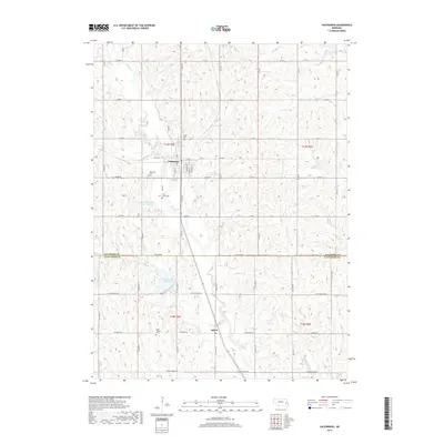
2017 Map of Valparaiso
USGS Topo · Published 2017About this map
Valparaiso serves as the primary hub in this portion of the Nebraska landscape, situated near the confluence of N Oak Cr and Bates Br. The area is characterized by the complex drainage systems of the Oak Creek watershed, including North Oak Creek Reservoir 2-C and North Oak Creek Reservoir 1-A. Further south, the small community of Agnew marks the intersection of W Agnew Rd and Highway 79. The map preserves the locations of several burial grounds essential for genealogical research, such as Saint Marys Cem and Saint Joseph Cem. The transition across the Saunders Co Lancaster Co line highlights the shifting agricultural and civil boundaries that have structured these rural townships since the late 19th century.
Find a feature on this map
34 named features on this map. Tap any name to fly to it.
Don’t see what you’re looking for? This feature index may not catch every label — zoom into the map to look around manually.
Map Details
Editions of this 2017 Valparaiso Map
This is the sole edition of this map. No revisions or reprints were ever made.
Other maps of this area

1897 · Lincoln
USGS Topo · 1:125,000

1899 · Wahoo
USGS Topo · 1:125,000

1955 · Fremont
USGS Topo · 1:250,000

1955 · Lincoln
USGS Topo · 1:250,000

1957 · Fremont
USGS Topo · 1:250,000

1957 · Lincoln
USGS Topo · 1:250,000

1958 · Fremont
USGS Topo · 1:250,000

1958 · Lincoln
USGS Topo · 1:250,000
1964 · Garland
USGS Topo · 1:24,000

1964 · Davey
USGS Topo · 1:24,000