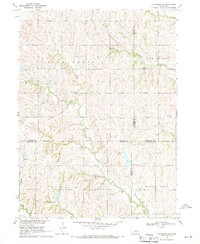
1969 Map of Valparaiso SW
USGS Topo · Published 1971About this map
Oak Creek and its various tributaries, including Bates Branch and Wagon Tongue Creek, define the landscape of this rural Nebraska quadrangle. In the late 1960s, this area served as a crossroads for four counties—Butler, Saunders, Seward, and Lancaster—creating a complex web of jurisdictional boundaries across the agricultural terrain. The Union Pacific railroad corridor cuts through the northern section, following the natural path provided by the creek valley. Local education is represented by the Oak Ridge Sch in the eastern hills, while resource extraction is noted at a Quarry near the southern map edge. A distinct hydraulic feature, the Flowing Well, is marked in the central valley, indicating the importance of groundwater in this productive prairie region. The map captures a moment of established rural infrastructure just before modernization changed the local school and rail networks.
Find a feature on this map
16 named features on this map. Tap any name to fly to it.
Don’t see what you’re looking for? This feature index may not catch every label — zoom into the map to look around manually.
Map Details
Editions of this 1969 Valparaiso SW Map
This is the sole edition of this map. No revisions or reprints were ever made.
Other maps of this area

1897 · Lincoln
USGS Topo · 1:125,000

1899 · Wahoo
USGS Topo · 1:125,000

1899 · David City
USGS Topo · 1:125,000

1934 · Seward
USGS Topo · 1:48,000

1939 · Seward
USGS Topo · 1:62,500

1955 · Fremont
USGS Topo · 1:250,000

1955 · Lincoln
USGS Topo · 1:250,000

1957 · Fremont
USGS Topo · 1:250,000

1957 · Lincoln
USGS Topo · 1:250,000

1958 · Fremont
USGS Topo · 1:250,000