
1941 Map of Vamori
USGS Topo · Published 1958About this map
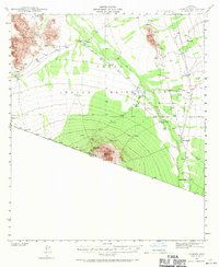
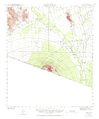
The Papago Indian Reservation dominates this desert landscape along the international border in southern Arizona. Surveyed just as the United States entered the second World War, the map records a series of traditional O'odham settlements connected by unimproved dirt roads and trails. Central to the geography are the Alvarez Mountains and the Vamori Valley, where drainage like the Vamori Wash dictates the location of villages and cattle tanks. Notable hubs such as Vamori, Choulic, and San Miguel appear with their local cemeteries and wells, while the San Agustin Ranch sits at the base of Morena Mountain. The southern edge is defined by the United States Mexico border, showing the proximity of the Arizona Sonora boundary to remote outposts like Hashan Chuelig.
Find a feature on this map
25 named features on this map. Tap any name to fly to it.
Don’t see what you’re looking for? This feature index may not catch every label — zoom into the map to look around manually.
Map Details
Editions of this 1941 Vamori Map
3 editions found
Other maps of this area

1941 · Presumido Peak
USGS Topo · 1:62,500

1941 · Baboquivari Peak
USGS Topo · 1:62,500

1941 · Sells
USGS Topo · 1:62,500

1943 · Sells
USGS Topo · 1:62,500

1943 · Fresnal
USGS Topo · 1:125,000

1943 · Presumido Peak
USGS Topo · 1:62,500

1943 · Vamori
USGS Topo · 1:62,500

1944 · Baboquivari Peak
USGS Topo · 1:62,500

1954 · Sonoyta
USGS Topo · 1:250,000

1956 · Nogales
USGS Topo · 1:250,000
Featured Places
- Topawa, AZ
- Chukut Kuk District, AZ
- Haivan Vaya, Chukut Kuk District
- San Agustin, Chukut Kuk District
- Choulic, Topawa