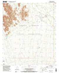
1996 Map of Vamori
USGS Topo · Published 2003About this map
The Tohono O'odham Indian Reservation dominates this desert landscape, where the Alvarez Mountains rise sharply out of the flat basin. The small settlement of Vamori sits at the edge of the Vamori Valley, characterized by seasonal drainage patterns like Vamori Wash and localized water sources such as Wamul Tank. Toward the south, the international boundary with Sonora, Mexico, cuts across the terrain, passing just south of Wolfley Hill and Tecolote Ranch. The presence of several unmarked Cem labels near Itak and Vamori provides significant points of interest for genealogists and local historians tracing families within the O'odham lands. The topography reveals the stark isolation of the high desert, punctuated by landmarks like Rocky Point, which serve as visual anchors in this expansive Pima County region.
Find a feature on this map
15 named features on this map. Tap any name to fly to it.
Don’t see what you’re looking for? This feature index may not catch every label — zoom into the map to look around manually.
Map Details
Editions of this 1996 Vamori Map
This is the sole edition of this map. No revisions or reprints were ever made.
Other maps of this area

1941 · Vamori
USGS Topo · 1:62,500

1941 · Sells
USGS Topo · 1:62,500

1943 · Sells
USGS Topo · 1:62,500

1943 · Fresnal
USGS Topo · 1:125,000

1943 · Vamori
USGS Topo · 1:62,500

1954 · Sonoyta
USGS Topo · 1:250,000

1956 · Nogales
USGS Topo · 1:250,000

1958 · Nogales
USGS Topo · 1:250,000

1959 · Nogales
USGS Topo · 1:250,000

1963 · Gu Oidak
USGS Topo · 1:62,500