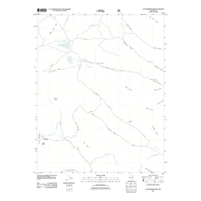
2011 Map of Van Bremmer Park
USGS Topo · Published 2011About this map
Ring Place and the surrounding high country of Colfax County define this landscape at the edge of the Sangre de Cristo foothills. The map reveals a network of canyons and high parks, where seasonal camps like Bremmer Longshed Camp and Cerrososo Camp are connected by forest roads such as FR 1950. The drainage systems of Van Bremmer Creek and Cerrososo Creek carve through the terrain, creating distinct landforms like Whiteman Vega and Rock Park.
Find a feature on this map
33 named features on this map. Tap any name to fly to it.
Don’t see what you’re looking for? This feature index may not catch every label — zoom into the map to look around manually.
Map Details
Editions of this 2011 Van Bremmer Park Map
This is the sole edition of this map. No revisions or reprints were ever made.
Other maps of this area

1954 · Raton
USGS Topo · 1:250,000

1955 · Cimarron
USGS Topo · 1:62,500

1955 · Ute Park
USGS Topo · 1:62,500

1958 · Raton
USGS Topo · 1:250,000

1962 · Ash Mountain
USGS Topo · 1:62,500

1962 · Casa Grande
USGS Topo · 1:62,500

1981 · Raton
USGS Topo · 1:100,000

1982 · Wheeler Peak
USGS Topo · 1:100,000
1986 · Vermejo Park
USGS Topo · 1:24,000
1986 · Van Bremmer Park
USGS Topo · 1:24,000