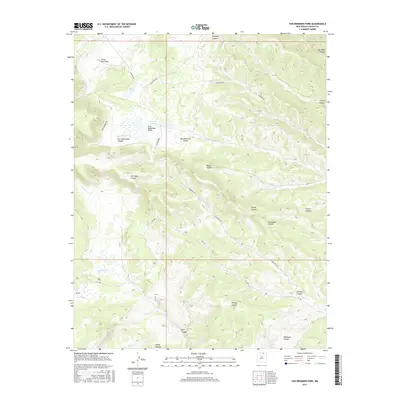
2017 Map of Van Bremmer Park
USGS Topo · Published 2017About this map
Van Bremmer Park and Castle Rock Park define this stretch of the New Mexico high country, where the landscape is carved by an intricate network of drainages. The naming conventions throughout the quadrangle reflect a history of local land use and family-named landmarks, such as Harry Bremmer Canyon and Marys Lake. Moving through the center of the sheet, Cimarron Rd and Gachupin Rd provide access to the interior, tracing paths through Van Bremmer Canyon and Broad Canyon. Significant water features like the Bremmer Lakes and the winding course of Van Bremmer Creek anchor the northern section, while the southern reaches are dominated by steep relief and named features like Graveyard Canyon and Metcalf Canyon. This map captures a rugged topography largely shaped by its canyons and the seasonal flows of creeks like McCrystal Creek.
Find a feature on this map
30 named features on this map. Tap any name to fly to it.
Don’t see what you’re looking for? This feature index may not catch every label — zoom into the map to look around manually.
Map Details
Editions of this 2017 Van Bremmer Park Map
This is the sole edition of this map. No revisions or reprints were ever made.
Other maps of this area

1954 · Raton
USGS Topo · 1:250,000

1955 · Cimarron
USGS Topo · 1:62,500

1955 · Ute Park
USGS Topo · 1:62,500

1958 · Raton
USGS Topo · 1:250,000

1962 · Ash Mountain
USGS Topo · 1:62,500

1962 · Casa Grande
USGS Topo · 1:62,500

1981 · Raton
USGS Topo · 1:100,000

1982 · Wheeler Peak
USGS Topo · 1:100,000
1986 · Vermejo Park
USGS Topo · 1:24,000
1986 · Van Bremmer Park
USGS Topo · 1:24,000