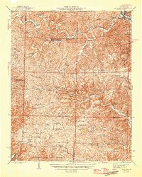
1946 Map of Van Buren
USGS Topo · Published 1946About this map
The Current River defines the northeastern corner of this Ozark landscape, where the settlement of Van Buren sits across the water from Chicopee. This 1946 edition highlights a rural economy transitioning from timber to conservation, showing the vast Mark Twain National Forest and the Wilderness State Game Refuge blanketing the southern hills. Transportation history is visible through the St Louis San Francisco railroad and remnants of the logging era like the Tram Road. Scattered through the hollows are small community hubs, including Handy and Wilderness, supported by local institutions like Gum Spring Sch and Barren Church. Numerous ponds, such as Cupola Pond and Camp Five Pond, provide rare water sources in this upland terrain, while fire lookouts like Eagle Lookout and Fremont Lookout reflect the era's focus on forest management.
Find a feature on this map
59 named features on this map. Tap any name to fly to it.
Don’t see what you’re looking for? This feature index may not catch every label — zoom into the map to look around manually.
Map Details
Editions of this 1946 Van Buren Map
2 editions found

Other maps of this area

1915 · Eminence
USGS Topo · 1:62,500

1917 · Eminence
USGS Topo · 1:62,500

1928 · Cardareva
USGS Topo · 1:62,500

1931 · Bandyville
USGS Topo · 1:48,000

1939 · Doniphan
USGS Topo · 1:62,500

1941 · Gatewood
USGS Topo · 1:62,500

1943 · Ellington
USGS Topo · 1:62,500

1944 · Van Buren
USGS Topo · 1:62,500

1944 · Couch
USGS Topo · 1:62,500

1944 · Birch Tree
USGS Topo · 1:62,500