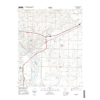
2017 Map of Van Buren
USGS Topo · Published 2017About this map
The Arkansas River corridor defines the geography of this survey, where the river serves as the dividing line between Van Buren in Crawford County and Fort Smith in Sebastian County. The landscape is a mix of dense municipal development and flood-plain features like Hollis Lake and Crain Lake. Transportation infrastructure is a central theme, with the Kansas City Southern RR and numerous bridges, including the Broadway Bridge and Byrns Bridge, facilitating movement across the water. For local history and genealogy, the map identifies several smaller community nodes such as Smeltzer, Shibley, and Oak Grove, alongside a high concentration of burial grounds including Antioch Cem, Grace Lawn Cem, and Rose Lawn Cem. The survey also marks the institutional presence of the Univ of Arkansas Ft Smith on the western edge of the quadrangle.
Find a feature on this map
121 named features on this map. Tap any name to fly to it.
Don’t see what you’re looking for? This feature index may not catch every label — zoom into the map to look around manually.
Map Details
Editions of this 2017 Van Buren Map
This is the sole edition of this map. No revisions or reprints were ever made.
Other maps of this area

1879 · Fort Smith
USGS Topo · 1:62,500

1887 · Van Buren
USGS Topo · 1:62,500

1890 · Fort Smith
USGS Topo · 1:125,000

1898 · Winslow #4
USGS Topo · 1:62,500

1898 · Winslow #3
USGS Topo · 1:62,500

1898 · Winslow
USGS Topo · 1:125,000

1901 · Winslow
USGS Topo · 1:125,000

1906 · Lavaca
USGS Topo · 1:62,500

1943 · Fort Smith
USGS Topo · 1:125,000

1946 · Fort Smith
USGS Topo · 1:250,000