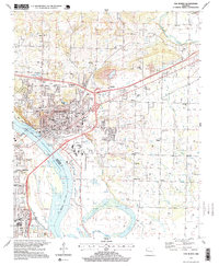
1997 Map of Van Buren
USGS Topo · Published 1999About this map
Van Buren sits at a strategic bend in the Arkansas River, serving as a focal point for Crawford County transportation and industry in the late 1990s. The map illustrates a landscape transitioning from the dense urban grid of the riverfront, featuring landmarks like the Courthouse and Armory, to the residential developments of Rena and Hillcrest. The influence of the river is prominent, with the Fort Smith city limits appearing on the southern bank near T.G. Smith Park.
Find a feature on this map
89 named features on this map. Tap any name to fly to it.
Don’t see what you’re looking for? This feature index may not catch every label — zoom into the map to look around manually.
Map Details
Editions of this 1997 Van Buren Map
This is the sole edition of this map. No revisions or reprints were ever made.
Other maps of this area

1879 · Fort Smith
USGS Topo · 1:62,500

1887 · Van Buren
USGS Topo · 1:62,500

1890 · Fort Smith
USGS Topo · 1:125,000

1898 · Winslow #4
USGS Topo · 1:62,500

1898 · Winslow #3
USGS Topo · 1:62,500

1898 · Winslow
USGS Topo · 1:125,000

1901 · Winslow
USGS Topo · 1:125,000

1906 · Lavaca
USGS Topo · 1:62,500

1943 · Fort Smith
USGS Topo · 1:125,000

1946 · Fort Smith
USGS Topo · 1:250,000