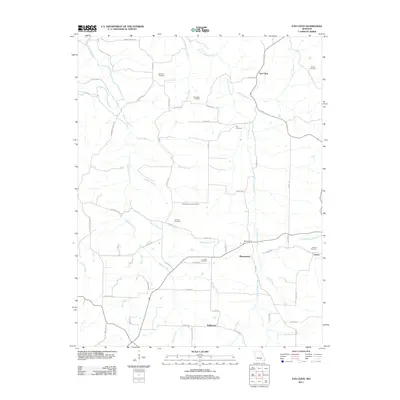
2011 Map of Van Cleve
USGS Topo · Published 2011About this map
Van Cleve and its historical counterpart Old Van Cleve anchor this rural landscape in Maries County, where a network of family-named cemeteries and narrow creek valleys defines the local geography. The map documents a deeply rooted agricultural community through the distribution of sites like Barnhart Cemetery, Stokes Cemetery, and Jim-Matt Lawson Cemetery. Waterways including Tavern Creek, Little Tavern Creek, and Wiemer Creek dictate the positioning of settlements such as Meyerstown and Sudheimer. The convergence of Tavern Creek and Berry Creek near the settlement of Tavern illustrates the traditional reliance on these drainage systems for orientation and movement through the region. This 2011 survey provides a contemporary perspective on historical land patterns, preserving the names of rural thoroughfares like Kemna Bridge Rd and Brays Mill Rd that connect isolated homesteads to the broader county infrastructure.
Find a feature on this map
62 named features on this map. Tap any name to fly to it.
Don’t see what you’re looking for? This feature index may not catch every label — zoom into the map to look around manually.
Map Details
Editions of this 2011 Van Cleve Map
This is the sole edition of this map. No revisions or reprints were ever made.
Other maps of this area

1888 · Tuscumbia
USGS Topo · 1:125,000

1894 · Tuscumbia
USGS Topo · 1:125,000

1933 · Iberia
USGS Topo · 1:62,500

1937 · Iberia
USGS Topo · 1:62,500

1947 · Jefferson City
USGS Topo · 1:250,000

1948 · Meta
USGS Topo · 1:62,500
1948 · Eugene
USGS Topo · 1:62,500

1948 · Tavern
USGS Topo · 1:62,500
1950 · Meta
USGS Topo · 1:62,500
1950 · Tavern
USGS Topo · 1:62,500