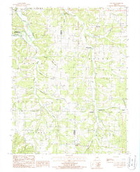
1987 Map of Van Cleve
USGS Topo · Published 1987About this map
Tavern Creek and its many winding tributaries dictate the landscape of this central Missouri region, where the borders of Jim Henry, Osage, Boone, and Richwoods townships converge. The map documents a rural network of small settlements and agricultural creek bottoms during the late 1980s, including Van Cleve, Old Van Cleve, Meyerstown, and Sudheimer. Of particular note is the Boeckman Bridge State Wildlife Area situated near the sand areas of the creek. Numerous unnamed cemeteries are scattered throughout the hills, providing valuable data for genealogists tracing families along Greasy Creek, Berry Creek, and Shelton Branch. The presence of the wooden pole trans line and several creek crossings, such as those on Wiemer Creek and Duncan Branch, highlight the local infrastructure of the era.
Find a feature on this map
28 named features on this map. Tap any name to fly to it.
Don’t see what you’re looking for? This feature index may not catch every label — zoom into the map to look around manually.
Map Details
Editions of this 1987 Van Cleve Map
This is the sole edition of this map. No revisions or reprints were ever made.
Other maps of this area

1888 · Tuscumbia
USGS Topo · 1:125,000

1894 · Tuscumbia
USGS Topo · 1:125,000

1933 · Iberia
USGS Topo · 1:62,500

1937 · Iberia
USGS Topo · 1:62,500

1947 · Jefferson City
USGS Topo · 1:250,000

1948 · Meta
USGS Topo · 1:62,500
1948 · Eugene
USGS Topo · 1:62,500

1948 · Tavern
USGS Topo · 1:62,500
1950 · Meta
USGS Topo · 1:62,500
1950 · Tavern
USGS Topo · 1:62,500