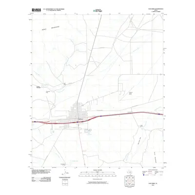
2010 Map of Van Horn
USGS Topo · Published 2010About this map
Van Horn serves as the central hub of this Trans-Pecos landscape, situated at the intersection of modern interstate travel and historical routes like the Old Bankhead Hwy. The town's grid is established in a high desert basin, flanked by the prominent Beach Mountains to the northwest and the Wylie Mountains to the southeast. Ranching history is evident through family-named landmarks such as Neal Ranch and Lipsey Ranch, while the local economy is anchored by the Culberson County Airport. To the south, water management in this arid environment is highlighted by the Harold Martin Lake Dam near Farmer Lake. The surrounding terrain features dry watercourses like Wild Horse Draw and Carrizo Creek, which define the drainage patterns of the region's rugged topography.
Find a feature on this map
22 named features on this map. Tap any name to fly to it.
Don’t see what you’re looking for? This feature index may not catch every label — zoom into the map to look around manually.
Map Details
Editions of this 2010 Van Horn Map
This is the sole edition of this map. No revisions or reprints were ever made.
Other maps of this area

1892 · Chispa
USGS Topo · 1:125,000

1895 · Chispa
USGS Topo · 1:125,000

1897 · Chispa
USGS Topo · 1:125,000

1906 · Van Horn
USGS Topo · 1:125,000

1954 · Van Horn
USGS Topo · 1:250,000

1958 · Van Horn
USGS Topo · 1:250,000

1959 · Marfa
USGS Topo · 1:250,000

1964 · Wild Horse
USGS Topo · 1:24,000
1964 · Hackett Peak
USGS Topo · 1:24,000

1964 · Watson Ranch
USGS Topo · 1:24,000