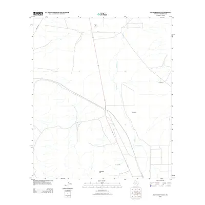
2012 Map of Van Horn Wells
USGS Topo · Published 2012About this map
Van Horn Wells sits at the heart of this Trans-Pecos landscape, marking a vital water point in the arid terrain of Lobo Valley. The map illustrates a ranching economy defined by isolated outposts such as Farmer Ranch and Waddell Ranch, connected by a network of long, straight desert roads like Lobo Rd and 101 Rd. The topography is dominated by the seasonal hydrology of Eagle Flat Draw and the meandering path of Wild Horse Creek, which drain toward the valley floor. To the south, Heliograph Hill rises as a prominent landmark, its name a nod to the historical use of signaling stations in this expansive territory. This 2012 survey reveals how the modern highway system follows the same corridors established by these early desert water sources and cattle operations.
Find a feature on this map
11 named features on this map. Tap any name to fly to it.
Don’t see what you’re looking for? This feature index may not catch every label — zoom into the map to look around manually.
Map Details
Editions of this 2012 Van Horn Wells Map
This is the sole edition of this map. No revisions or reprints were ever made.
Other maps of this area

1892 · Chispa
USGS Topo · 1:125,000

1895 · Chispa
USGS Topo · 1:125,000

1897 · Chispa
USGS Topo · 1:125,000

1906 · Van Horn
USGS Topo · 1:125,000

1954 · Van Horn
USGS Topo · 1:250,000

1958 · Van Horn
USGS Topo · 1:250,000

1959 · Marfa
USGS Topo · 1:250,000

1964 · Wild Horse
USGS Topo · 1:24,000
1964 · Hackett Peak
USGS Topo · 1:24,000

1964 · Van Horn
USGS Topo · 1:24,000