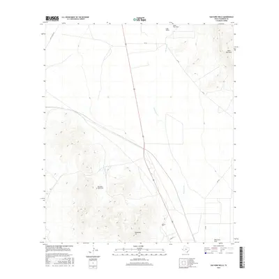
2016 Map of Van Horn Wells
USGS Topo · Published 2016About this map
Van Horn Wells sits at the intersection of arid high-desert terrain and significant Trans-Pecos drainage systems. This area is defined by the broad Lobo Valley, which serves as a natural corridor between the towering Van Horn Mountains to the southwest and the Wylie Mountains to the northeast. The geography is marked by ephemeral waterways like Wild Horse Cr and Eagle Flat Draw, illustrating the complex watershed of Culberson County. Heliograph Hill rises prominently in the south, a name suggesting the historical importance of this high ground for long-distance optical signaling. A network of rural routes, including Scott Crossing Rd and Lobo Rd, provides access to these isolated ranges, tracing a landscape that remains primarily defined by its physical geology rather than dense settlement.
Find a feature on this map
12 named features on this map. Tap any name to fly to it.
Don’t see what you’re looking for? This feature index may not catch every label — zoom into the map to look around manually.
Map Details
Editions of this 2016 Van Horn Wells Map
This is the sole edition of this map. No revisions or reprints were ever made.
Other maps of this area

1892 · Chispa
USGS Topo · 1:125,000

1895 · Chispa
USGS Topo · 1:125,000

1897 · Chispa
USGS Topo · 1:125,000

1906 · Van Horn
USGS Topo · 1:125,000

1954 · Van Horn
USGS Topo · 1:250,000

1958 · Van Horn
USGS Topo · 1:250,000

1959 · Marfa
USGS Topo · 1:250,000

1964 · Wild Horse
USGS Topo · 1:24,000
1964 · Hackett Peak
USGS Topo · 1:24,000

1964 · Van Horn
USGS Topo · 1:24,000