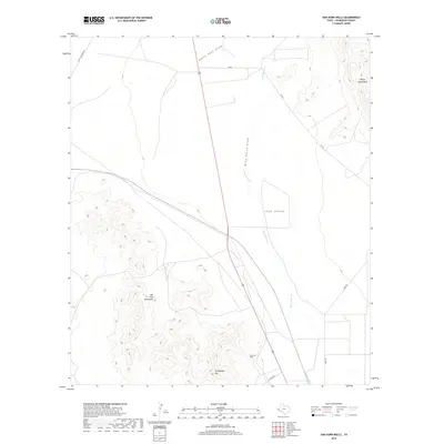
2019 Map of Van Horn Wells
USGS Topo · Published 2019About this map
Van Horn Wells sits at the base of the Van Horn Mountains in this high-desert portion of Culberson County. The landscape is defined by the broad Lobo Valley, a transition zone between the sharp topography of the Wylie Mountains to the northeast and the southern peaks including Heliograph Hill. Water movement in this arid environment is recorded through the complex drainage systems of Eagle Flat Draw, Wild Horse Draw, and Wild Horse Cr, which cut through the basin floor. Local transit and access to ranching lands are facilitated by a network of rural routes such as Lobo Rd, Owens Rd, and Scott Crossing Rd. This 2019 survey documents the contemporary state of these landforms and the sparsely distributed infrastructure of the Trans-Pecos region.
Find a feature on this map
12 named features on this map. Tap any name to fly to it.
Don’t see what you’re looking for? This feature index may not catch every label — zoom into the map to look around manually.
Map Details
Editions of this 2019 Van Horn Wells Map
This is the sole edition of this map. No revisions or reprints were ever made.
Other maps of this area

1892 · Chispa
USGS Topo · 1:125,000

1895 · Chispa
USGS Topo · 1:125,000

1897 · Chispa
USGS Topo · 1:125,000

1906 · Van Horn
USGS Topo · 1:125,000

1954 · Van Horn
USGS Topo · 1:250,000

1958 · Van Horn
USGS Topo · 1:250,000

1959 · Marfa
USGS Topo · 1:250,000

1964 · Wild Horse
USGS Topo · 1:24,000
1964 · Hackett Peak
USGS Topo · 1:24,000

1964 · Van Horn
USGS Topo · 1:24,000